
Stour Valley Underground’s Initial Outline Response
to National Grid’s Undergrounding Decision
and Connection Options Report
Page 3 of 11
Stour Valley Underground advocate a number of alterations to National Grid's proposals as follows:
•That the underground route through the Stour Valley be altered to end south of the point proposed by NG. NG’s proposed end point is in a low lying, damp meadow near the Twinstead Tee (at Pylon 4YLA001). SVU propose an end point in lower value landscape 1.5km to the south at pylon 4YLA005. This will dramatically reduce visual blighting in a high landscape value tributary valley through the removal of 4 pylons and relocation of the proposed sealing end compound. The site we suggest has good road access and better drainage than the 4YLA001 site. The access lane for this site is highly robust and is not protected, unlike that for 4YLA001. The Ansell’s Grove County Wildlife Area would also see notable benefits in terms of the restoration of the woodland as outlined in our Benefits of SVU’s Proposals section, below.
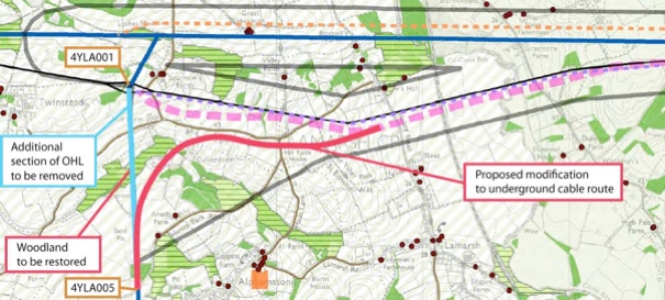
Map showing a possible alternative route alignment for the underground cable

Landscape at SVU proposed location for a sealing end compound.

Landscape at NG proposed site for a sealing end compound.